
Mervare-demoDet här är en demoprofil i Mervare, inte hamnens officiella tjänst. Båtplatser, tillgänglighet och bokning är exempeldata, inte bekräftad driftsinformation.
Some sailing-direction excerpts below are still in the original Estonian. They are source quotations, not translated navigation advice; consult the linked official publication and current notices before sailing.
I korthet
- 3 mPermitted draughtpilot book
- 57 mMaximum lengthregister
- 4 mMaximum beamregister
- 4.3 mQuay depthregister
- 1 maj – 30 septemberNavigation periodregister
Permitted draught is the limit the sailing directions publish for entering; quay depth is the register's figure for the deepest quay — other quays may be shallower. Neither guarantees a berth that suits your boat.
- laeva ümberpaigutamine on lubatud üksnes sadamakapteni teenistuse loaloriginal på estniska, inte översatt
- 12 m/stuule kiirusel üle 12 m/soriginal på estniska, inte översatt
- 50 mnähtavusel alla 50 moriginal på estniska, inte översatt
Service
- LandströmOkänd
- DuschOkänd
- WCOkänd
- KaféOkänd
- BränsleOkänd
- AvfallOkänd
- SlipOkänd
- ParkeringOkänd
- CykeluthyrningOkänd
Priser och tillgänglighet
Exempeldata: 18 gästplatser — en demo, inte hamnens verkliga tillgänglighet.
Bokning, båtuppgifter och betalning sker på mervare.app.
Besök hamnens egen Mervare-sidaGuest berth availability
Pick your arrival and departure to find a berth free for the whole stay.
Demo availability — does not reflect actual berth availability.
Loading availability…
Ankomst
Harju maakond, Kuusalu vald, Hara küla, Hara sadam, 74810
Hamnens omgivning
Inte för navigering. Se alla hamnar på kartan.
Visa i Nutimeri (Transpordiamet, opens in a new tab) — Transpordiamet
Officiella sjökort och sjömärken, endast som information — inte ett primärt navigeringshjälpmedel.
Seglingsanvisningar
Based on a published sailing directions guideLaevade üheaegsel sisse- ja väljasõidul kehtib sadamast väljuva laeva eesõigus, v.a. juhul kui tegu on hädaolukorraga laev peab liikuma minimaalse kiirusega, kuid mitte kiiremini kui 3 sõlme, ahtrilaine ei tohi tekkida. Vessel movements: laeva ümberpaigutamine on lubatud üksnes sadamakapteni teenistuse loal. Entry and departure ban: tuule kiirusel üle 12 m/s; nähtavusel alla 50 m.[2]
Använd tillsammans med ett aktuellt sjökort och navigationsvarningar.
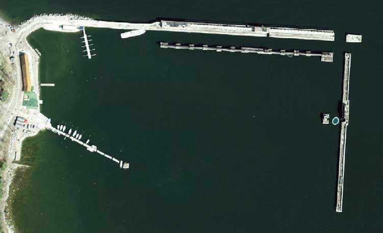
Depths and dimensional restrictions
The maximum permitted draught is 3.0 m. Published depths alongside range from 0.3 m to 4.3 m — shallowest at quay 1A, deepest at quay 8. Depths are referenced to EH2000.[2]
Djup per kaj (10)
| quay 8 | 4.3 m |
|---|---|
| quay 6 and 7 | 4.0 m |
| quay 5 | 3.5 m |
| quay 4 | 3.0 m |
| quay 3 | 2.5 m |
| quay 2 | 1.8 m |
| quay 9 | 1.3 m |
| quay 1B | 0.6 m |
| quay 1A | 0.3 m |
Källor
- Sailing directions Lootsiraamat 4.3 — Kaberneeme poolsaarest Narva jõeni
- Sailing directions Lootsiraamat 4.3 — Kaberneeme poolsaarest Narva jõeni
Publicerad 12 Sept 2026 · revision 4
Historisk vindstatistik
Prevailing winds
How often the wind blew FROM each direction, May–September 2021–2025.
Modelled data, not measured at the harbour
Rings: May (inside) → Sep (outside). Figure at the edge: share of the whole season.
The wind most often came from W (12 % of the season's hours).
- under 3 %
- 3–6 %
- 6–9 %
- 9–13 %
- 13–20 %
- 20 % or more
Regional model data cannot show how sheltered the harbour is, or how the wind moves around its piers and breakwaters.
Data as a table
| Wind from | May | Jun | Jul | Aug | Sep | Season |
|---|---|---|---|---|---|---|
| N | 4.3 % | 3.7 % | 2.1 % | 3.5 % | 4.8 % | 3.7 % |
| NNE | 3.3 % | 3.6 % | 2.5 % | 2.3 % | 2.3 % | 2.8 % |
| NE | 4.7 % | 3.5 % | 4.9 % | 3.3 % | 2.4 % | 3.8 % |
| ENE | 5.3 % | 4.7 % | 6.7 % | 4.9 % | 4.8 % | 5.3 % |
| E | 3.8 % | 4.3 % | 3.9 % | 4.7 % | 4.3 % | 4.2 % |
| ESE | 3.8 % | 4.2 % | 3.4 % | 5.4 % | 5.2 % | 4.4 % |
| SE | 3.4 % | 3.1 % | 4.9 % | 5.5 % | 9.7 % | 5.3 % |
| SSE | 3.8 % | 4.4 % | 5.0 % | 7.6 % | 12 % | 6.6 % |
| S | 5.0 % | 5.3 % | 3.9 % | 7.6 % | 9.1 % | 6.1 % |
| SSW | 6.3 % | 6.0 % | 7.6 % | 9.0 % | 8.9 % | 7.6 % |
| SW | 7.3 % | 9.1 % | 12 % | 11 % | 8.1 % | 9.5 % |
| WSW | 10 % | 11 % | 13 % | 12 % | 6.9 % | 11 % |
| W | 16 % | 15 % | 13 % | 9.2 % | 5.2 % | 12 % |
| WNW | 11 % | 10 % | 8.7 % | 6.6 % | 4.9 % | 8.2 % |
| NW | 6.4 % | 7.8 % | 5.5 % | 4.2 % | 5.7 % | 5.9 % |
| NNW | 5.4 % | 3.7 % | 2.5 % | 2.7 % | 5.2 % | 3.9 % |
| calm | 0.8 % | 0.7 % | 0.8 % | 0.9 % | 0.5 % | 0.7 % |
| % | 100 % | 100 % | 100 % | 100 % | 100 % | 100 % |
Calm: below 0.5 m/s; counted in the total, not in any direction. 18360 valid hours of 18360 expected.
Source: ERA5 reanalysis (ECMWF / Copernicus Climate Change Service), ~25 km grid · model grid point 11.7 km south-west of the harbour (59.500, 25.500) · May–September 2021–2025, UTC · 18360 valid hours of 18360 expected · Data retrieved 2026-10-07 · Contains modified Copernicus Climate Change Service information (ERA5), CC BY 4.0
Data: hamnregister, posten uppdaterad 31 Dec 2025.
Visitor observations
Sailors' experiences, not the harbour's official information.
Praktisk information och hamndokument
- Adress
- Harju maakond, Kuusalu vald, Hara küla, Hara sadam, 74810
- Navigeringsperiod
- 1. mai - 30. september
- Hamnkapten
- Tarvi Velström
- Position
- 59.58810° N, 25.61240° E
- Telefon
- +37256900433
- E-post
- info@harasadam.ee
- Webbplats
- harasadam.ee
Alla tjänster i registret
Veesõiduki sildumise võimaldamine · Veeliikluse korraldamine akvatooriumil ja sissesõiduteel · Kütus · Parkla · Slipi kasutamise võimaldamine · WC · Muu · Pesemisvõimaluste pakkumine · Elekter · Jalgrataste laenutamine · Kohvik/Restoran · Prügivastuvõtt · Veesõidukite laenutamine
Närmaste hamnar
Avstånd fågelvägen. Närmast betyder inte att hamnen passar din båt.
Tallinnviken, Paldiski, Naissaar och Aegna, samt västra halvan av Lahemaa ut till Kolga och Hara. Korta etapper och de flesta tjänster öppna året runt. Alla hamnar i Harju län och Tallinn →
The story behind this place
Rauno of Pirate’s Eye filmed Hara’s former submarine base and marina. Watch the full film here. This Mervare profile is a product demo, not an official harbour service.
Hara Marina — full film
Suggest a video for this harbour
Add a 3–30 second video file or a YouTube link. Videos are reviewed before publication; a suitable short clip may become the page hero.