Taaliku sadam
Saaremaa och Muhu · Väinameri
I korthet
- 1.1 mPermitted draughtpilot book
- 42.5 mMaximum lengthregister
- 4 mMaximum beamregister
- 1.4 mQuay depthregister
- 1 mars – 1 decemberNavigation periodregister
Permitted draught is the limit the sailing directions publish for entering; quay depth is the register's figure for the deepest quay — other quays may be shallower. Neither guarantees a berth that suits your boat.
Service
- LandströmOkänd
- WCOkänd
- ParkeringOkänd
Priser och tillgänglighet
Priset är inte publicerat — fråga hamnen. Bekräfta priser, tillgänglighet för dina datum och inkluderad service med hamnen.
Kom överens om plats, pris och ankomst direkt med hamnen.
Ankomst
Saare maakond, Saaremaa vald, Pulli küla, Taaliku sadam, 94612
Hamnens omgivning
Inte för navigering. Se alla hamnar på kartan.
Visa i Nutimeri (Transpordiamet, opens in a new tab) — Transpordiamet
Officiella sjökort och sjömärken, endast som information — inte ett primärt navigeringshjälpmedel.
Seglingsanvisningar
Based on a published sailing directions guideAnvänd tillsammans med ett aktuellt sjökort och navigationsvarningar.
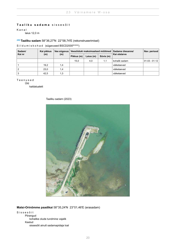
Depths and dimensional restrictions
The maximum permitted draught is 1.1 m. Published depths alongside are quay 1: 1.4 m, quay 2: 1.4 m and quay 3: 1.3 m. Depths are referenced to EH2000.[2]
Djup per kaj (3)
| quay 1 and 2 | 1.4 m |
|---|---|
| quay 3 | 1.3 m |
Källor
- Sailing directions Lootsiraamat 2.3 — Väinamere W osa
- Sailing directions Lootsiraamat 2.3 — Väinamere W osa
Publicerad 12 Sept 2026 · revision 4
Historisk vindstatistik
Prevailing winds
How often the wind blew FROM each direction, May–September 2021–2025.
Modelled data, not measured at the harbour
Rings: May (inside) → Sep (outside). Figure at the edge: share of the whole season.
The wind most often came from SW (12 % of the season's hours).
- under 3 %
- 3–6 %
- 6–9 %
- 9–13 %
- 13–20 %
- 20 % or more
Regional model data cannot show how sheltered the harbour is, or how the wind moves around its piers and breakwaters.
Data as a table
| Wind from | May | Jun | Jul | Aug | Sep | Season |
|---|---|---|---|---|---|---|
| N | 4.7 % | 4.0 % | 3.5 % | 3.8 % | 5.9 % | 4.4 % |
| NNE | 5.4 % | 3.9 % | 2.9 % | 2.7 % | 4.6 % | 3.9 % |
| NE | 5.0 % | 2.4 % | 4.1 % | 3.3 % | 2.2 % | 3.4 % |
| ENE | 3.6 % | 2.3 % | 4.8 % | 3.7 % | 3.1 % | 3.5 % |
| E | 4.1 % | 3.7 % | 4.0 % | 3.0 % | 4.2 % | 3.8 % |
| ESE | 3.9 % | 3.7 % | 3.8 % | 3.5 % | 6.7 % | 4.3 % |
| SE | 4.1 % | 3.6 % | 3.7 % | 5.6 % | 8.5 % | 5.1 % |
| SSE | 7.2 % | 7.4 % | 5.5 % | 7.6 % | 9.0 % | 7.3 % |
| S | 7.0 % | 7.1 % | 5.0 % | 8.2 % | 7.8 % | 7.0 % |
| SSW | 9.3 % | 6.3 % | 6.7 % | 8.7 % | 7.2 % | 7.7 % |
| SW | 8.5 % | 13 % | 17 % | 13 % | 10.0 % | 12 % |
| WSW | 8.7 % | 12 % | 14 % | 11 % | 7.9 % | 11 % |
| W | 6.1 % | 7.9 % | 8.0 % | 7.6 % | 6.5 % | 7.2 % |
| WNW | 6.6 % | 6.9 % | 6.0 % | 7.9 % | 4.5 % | 6.4 % |
| NW | 8.7 % | 8.9 % | 5.2 % | 5.6 % | 5.1 % | 6.7 % |
| NNW | 6.6 % | 5.9 % | 5.7 % | 4.5 % | 6.8 % | 5.9 % |
| calm | 0.4 % | 0.7 % | 0.4 % | 0.3 % | 0.2 % | 0.4 % |
| % | 100 % | 100 % | 100 % | 100 % | 100 % | 100 % |
Calm: below 0.5 m/s; counted in the total, not in any direction. 18360 valid hours of 18360 expected.
Source: ERA5 reanalysis (ECMWF / Copernicus Climate Change Service), ~25 km grid · model grid point 11.7 km south of the harbour (58.500, 23.000) · May–September 2021–2025, UTC · 18360 valid hours of 18360 expected · Data retrieved 2026-10-07 · Contains modified Copernicus Climate Change Service information (ERA5), CC BY 4.0
Data: hamnregister, posten uppdaterad 17 Nov 2025.
Visitor observations
Sailors' experiences, not the harbour's official information.
Praktisk information och hamndokument
- Adress
- Saare maakond, Saaremaa vald, Pulli küla, Taaliku sadam, 94612
- Navigeringsperiod
- 1. märts - 1. detsember
- Position
- 58.60457° N, 22.97920° E
- Telefon
- +372 53452698
- E-post
- urmasmagi1963@hot.ee
Alla tjänster i registret
Veesõiduki lastimine ja lossimine · Veesõiduki sildumise võimaldamine · Parkla · WC · Elekter
Närmaste hamnar
Avstånd fågelvägen. Närmast betyder inte att hamnen passar din båt.
Saaremaa, Muhu, Abruka och Vilsandi. Djupen i Väinameri är begränsade — djupgåendet är den avgörande faktorn här. Alla hamnar i Saaremaa och Muhu →
Suggest a video for this harbour
Add a 3–30 second video file or a YouTube link. Videos are reviewed before publication; a suitable short clip may become the page hero.