Soela sadam
Sāremā un Muhu · Väinameri
Ostas lapa vietnē mervare.ee ↗
Īsumā
- 1.7 mPermitted draughtpilot book
- 62.3 mMaximum lengthregister
- 5 mMaximum beamregister
- 1.8 mQuay depthregister
- 1. maijs – 31. oktobrisNavigation periodregister
Permitted draught is the limit the sailing directions publish for entering; quay depth is the register's figure for the deepest quay — other quays may be shallower. Neither guarantees a berth that suits your boat.
Pakalpojumi
- Krasta elektrībaUnknown
- ŪdensUnknown
- WCUnknown
- KafejnīcaUnknown
- DegvielaUnknown
- Wi-FiUnknown
- Laivu nolaišanas rampaUnknown
- AutostāvvietaUnknown
Cenas un pieejamība
Cena nav publicēta — jautājiet ostai. Apstipriniet ostā cenas, pieejamību jūsu datumos un cenā iekļautos pakalpojumus.
Vienojieties par vietu, cenu un ierašanos tieši ar ostu.
Ierašanās
Saare maakond, Saaremaa vald, Soela küla, Sadama, 94274
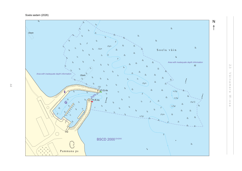
Ostas apkārtne
Nav izmantojams navigācijai. Skatīt visas ostas kartē.
Skatīt Nutimeri kartē (Transpordiamet, opens in a new tab) — Transpordiamet
Oficiālās navigācijas kartes un zīmes, tikai informatīvos nolūkos — nav galvenais navigācijas līdzeklis.
Kuģošanas norādes
Based on a published sailing directions guideLieto kopā ar aktuālu navigācijas karti un navigācijas brīdinājumiem.
- Soela sadam — aerial panorama (2023)Joel Tammet, estonia360.ee[1]
Depths and dimensional restrictions
The maximum permitted draught is 1.7 m. Published depths alongside range from 1.8 m to 1.8 m — shallowest at quay 1, deepest at quay 1. Depths are referenced to EH2000.[2]
Dziļumi pa piestātnēm (7)
| quay 1, 2, 3, 4, 5, 6 and 7 | 1.8 m |
|---|
Avoti
- Sailing directions Lootsiraamat 2.3 — Väinamere W osa
- Sailing directions Lootsiraamat 2.3 — Väinamere W osa
Publicēts 12 Sept 2026 · redakcija 4
Vēsturiskā vēja statistika
Prevailing winds
How often the wind blew FROM each direction, May–September 2021–2025.
Modelled data, not measured at the harbour
Rings: May (inside) → Sep (outside). Figure at the edge: share of the whole season.
The wind most often came from SW (12 % of the season's hours).
- under 3 %
- 3–6 %
- 6–9 %
- 9–13 %
- 13–20 %
- 20 % or more
Regional model data cannot show how sheltered the harbour is, or how the wind moves around its piers and breakwaters.
Data as a table
| Wind from | May | Jun | Jul | Aug | Sep | Season |
|---|---|---|---|---|---|---|
| N | 4.2 % | 3.4 % | 3.1 % | 3.6 % | 5.7 % | 4.0 % |
| NNE | 4.1 % | 2.2 % | 2.2 % | 2.0 % | 3.5 % | 2.8 % |
| NE | 4.1 % | 2.7 % | 3.3 % | 3.1 % | 2.1 % | 3.1 % |
| ENE | 4.3 % | 2.2 % | 5.0 % | 3.8 % | 3.1 % | 3.7 % |
| E | 4.1 % | 4.0 % | 4.5 % | 3.0 % | 4.5 % | 4.0 % |
| ESE | 4.7 % | 3.6 % | 3.6 % | 3.7 % | 6.5 % | 4.4 % |
| SE | 4.4 % | 4.2 % | 4.6 % | 6.2 % | 9.0 % | 5.7 % |
| SSE | 7.0 % | 6.0 % | 4.3 % | 6.9 % | 8.3 % | 6.5 % |
| S | 4.7 % | 6.3 % | 4.2 % | 7.9 % | 7.2 % | 6.0 % |
| SSW | 8.3 % | 6.5 % | 6.9 % | 9.5 % | 7.3 % | 7.7 % |
| SW | 9.5 % | 12 % | 15 % | 11 % | 9.9 % | 12 % |
| WSW | 8.8 % | 12 % | 15 % | 12 % | 8.3 % | 11 % |
| W | 8.1 % | 10 % | 9.1 % | 8.8 % | 7.2 % | 8.7 % |
| WNW | 7.8 % | 8.3 % | 6.4 % | 7.7 % | 4.2 % | 6.9 % |
| NW | 8.3 % | 9.5 % | 5.8 % | 5.8 % | 6.1 % | 7.1 % |
| NNW | 7.1 % | 5.9 % | 6.0 % | 5.1 % | 6.8 % | 6.2 % |
| calm | 0.4 % | 0.6 % | 0.6 % | 0.3 % | 0.4 % | 0.5 % |
| % | 100 % | 100 % | 100 % | 100 % | 100 % | 100 % |
Calm: below 0.5 m/s; counted in the total, not in any direction. 18360 valid hours of 18360 expected.
Source: ERA5 reanalysis (ECMWF / Copernicus Climate Change Service), ~25 km grid · model grid point 14.1 km south-west of the harbour (58.500, 22.500) · May–September 2021–2025, UTC · 18360 valid hours of 18360 expected · Data retrieved 2026-10-07 · Contains modified Copernicus Climate Change Service information (ERA5), CC BY 4.0
Dati: ostu reģistrs, ieraksts atjaunots 28 Nov 2025.
Skats no zemes
Visitor observations
Sailors' experiences, not the harbour's official information.
Praktiskā informācija un ostas dokumenti
- Adrese
- Saare maakond, Saaremaa vald, Soela küla, Sadama, 94274
- Navigācijas periods
- 1. mai - 31. oktoober
- Ostas kapteinis
- Raido Martinson
- Koordinātas
- 58.61727° N, 22.59326° E
- Tālrunis
- +372 57 222 222
- E-pasts
- info@soelasadam.ee
- Mājaslapa
- www.soelasadam.ee
Visi pakalpojumi reģistrā
Veesõiduki sildumise võimaldamine · Veeliikluse korraldamine akvatooriumil ja sissesõiduteel · Slipp · Wi-Fi · Joogivesi · Parkla · Kohvik/Restoran · Elekter · WC · Kütus
Tuvākās ostas
Attālums taisnā līnijā. Tuvākā osta nenozīmē, ka tā der jūsu laivai.
Sāremā, Muhu, Abrukas un Vilsandi. Dziļumi Vēnamerē ir nelieli — iegrime ir šeit galvenais ierobežojums. Visas Sāremā un Muhu ostas →
Suggest a video for this harbour
Add a 3–30 second video file or a YouTube link. Videos are reviewed before publication; a suitable short clip may become the page hero.