Kalasadam
Harju apriņķis un Tallina · Soome laht
Ostas lapa vietnē mervare.ee ↗
Īsumā
- 3 mPermitted draughtpilot book
- 63 mMaximum lengthregister
- 6 mMaximum beamregister
- 2.9 mQuay depthregister
- 1. aprīlis – 1. novembrisNavigation periodregister
Here the published draught (3 m) is greater than the deepest quay depth (2.9 m): the sources disagree or measure different places. Confirm with the harbour before arriving.
Permitted draught is the limit the sailing directions publish for entering; quay depth is the register's figure for the deepest quay — other quays may be shallower. Neither guarantees a berth that suits your boat.
Pakalpojumi
Apstiprināts pakalpojumu pārskats vēl nav pieejams. Tas nenozīmē, ka pakalpojumu nav.
Cenas un pieejamība
Cena nav publicēta — jautājiet ostai. Apstipriniet ostā cenas, pieejamību jūsu datumos un cenā iekļautos pakalpojumus.
Vienojieties par vietu, cenu un ierašanos tieši ar ostu.
Ierašanās
Harju maakond, Tallinn, Põhja-Tallinna linnaosa, Kalasadama 5, 10415
Ostas plāns
Nav izmantojams navigācijai. Skatīt visas ostas kartē.
Skatīt Nutimeri kartē (Transpordiamet, opens in a new tab) — Transpordiamet
Oficiālās navigācijas kartes un zīmes, tikai informatīvos nolūkos — nav galvenais navigācijas līdzeklis.
Kuģošanas norādes
Based on a published sailing directions guideSisenemine omal vastutusel.[2]
Lieto kopā ar aktuālu navigācijas karti un navigācijas brīdinājumiem.
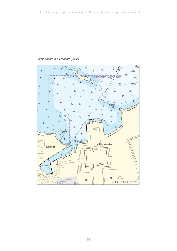
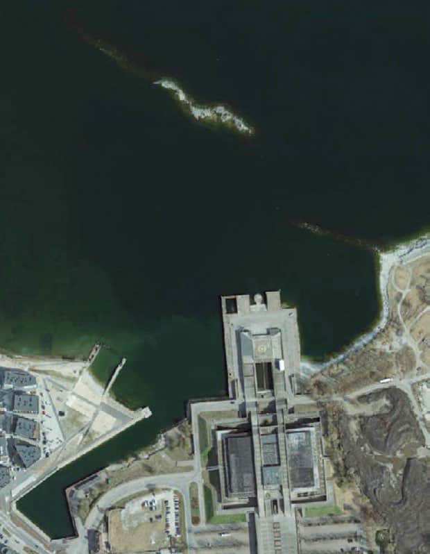
Depths and dimensional restrictions
The maximum permitted draught is 3.0 m. Published depths alongside are quay 3: 1.3 m and quay 5: 2.9 m. Depths are referenced to EH2000.[2]
Dziļumi pa piestātnēm (2)
| quay 5 | 2.9 m |
|---|---|
| quay 3 | 1.3 m |
Avoti
- Sailing directions Lootsiraamat 4.2 — Suurupi poolsaarest Kaberneeme poolsaareni
- Sailing directions Lootsiraamat 4.2 — Suurupi poolsaarest Kaberneeme poolsaareni
Publicēts 12 Sept 2026 · redakcija 4
Vēsturiskā vēja statistika
Prevailing winds
How often the wind blew FROM each direction, May–September 2021–2025.
Modelled data, not measured at the harbour
Rings: May (inside) → Sep (outside). Figure at the edge: share of the whole season.
The wind most often came from W (12 % of the season's hours).
- under 3 %
- 3–6 %
- 6–9 %
- 9–13 %
- 13–20 %
- 20 % or more
Regional model data cannot show how sheltered the harbour is, or how the wind moves around its piers and breakwaters.
Data as a table
| Wind from | May | Jun | Jul | Aug | Sep | Season |
|---|---|---|---|---|---|---|
| N | 4.2 % | 4.3 % | 2.7 % | 3.3 % | 4.6 % | 3.8 % |
| NNE | 3.4 % | 2.0 % | 2.1 % | 1.9 % | 2.9 % | 2.5 % |
| NE | 4.2 % | 2.7 % | 4.1 % | 3.5 % | 2.5 % | 3.4 % |
| ENE | 6.2 % | 5.2 % | 7.8 % | 5.3 % | 4.7 % | 5.8 % |
| E | 4.2 % | 4.9 % | 4.0 % | 4.8 % | 5.7 % | 4.7 % |
| ESE | 3.5 % | 3.7 % | 3.0 % | 4.6 % | 5.3 % | 4.0 % |
| SE | 3.1 % | 3.4 % | 4.5 % | 5.8 % | 9.3 % | 5.2 % |
| SSE | 3.3 % | 3.8 % | 4.7 % | 8.1 % | 11 % | 6.2 % |
| S | 4.8 % | 4.7 % | 3.5 % | 7.1 % | 8.0 % | 5.6 % |
| SSW | 5.8 % | 6.4 % | 7.1 % | 9.2 % | 8.1 % | 7.3 % |
| SW | 7.1 % | 9.9 % | 13 % | 10 % | 8.5 % | 9.7 % |
| WSW | 12 % | 13 % | 14 % | 12 % | 6.8 % | 11 % |
| W | 16 % | 14 % | 12 % | 9.8 % | 5.6 % | 12 % |
| WNW | 10 % | 10 % | 8.4 % | 6.8 % | 5.5 % | 8.2 % |
| NW | 5.7 % | 7.3 % | 5.3 % | 4.2 % | 5.7 % | 5.6 % |
| NNW | 5.0 % | 3.6 % | 2.6 % | 3.4 % | 5.2 % | 3.9 % |
| calm | 0.9 % | 0.9 % | 1.0 % | 0.3 % | 0.4 % | 0.7 % |
| % | 100 % | 100 % | 100 % | 100 % | 100 % | 100 % |
Calm: below 0.5 m/s; counted in the total, not in any direction. 18360 valid hours of 18360 expected.
Source: ERA5 reanalysis (ECMWF / Copernicus Climate Change Service), ~25 km grid · model grid point 5.9 km north of the harbour (59.500, 24.750) · May–September 2021–2025, UTC · 18360 valid hours of 18360 expected · Data retrieved 2026-10-07 · Contains modified Copernicus Climate Change Service information (ERA5), CC BY 4.0
Dati: ostu reģistrs, ieraksts atjaunots 13 Oct 2025.
Skats no zemes
Visitor observations
Sailors' experiences, not the harbour's official information.
Praktiskā informācija un ostas dokumenti
- Adrese
- Harju maakond, Tallinn, Põhja-Tallinna linnaosa, Kalasadama 5, 10415
- Navigācijas periods
- 1. aprill - 1. november
- Ostas kapteinis
- Karl-Gustav Annus
- Koordinātas
- 59.44724° N, 24.75061° E
- Tālrunis
- +372 6805400
- E-pasts
- info@kapitel.ee
Visi pakalpojumi reģistrā
Veesõiduki sildumise võimaldamine
Tuvākās ostas
Attālums taisnā līnijā. Tuvākā osta nenozīmē, ka tā der jūsu laivai.
Tallinas līcis, Paldiski, Naissāra un Aegna, kā arī Lahemā rietumu daļa līdz Kolgas un Haras līcim. Īsi pārgājieni, un lielākā daļa pakalpojumu pieejami visu gadu. Visas Harju apriņķis un Tallina ostas →
Suggest a video for this harbour
Add a 3–30 second video file or a YouTube link. Videos are reviewed before publication; a suitable short clip may become the page hero.