Loksa sadam
Harjun maakunta ja Tallinna · Soome laht
Sataman sivu sivustolla mervare.ee ↗
Lyhyesti
- 4 mPermitted draughtpilot book
- 171 mMaximum lengthregister
- 20 mMaximum beamregister
- 4 mQuay depthregister
- Ympäri vuodenNavigation periodregister
Permitted draught is the limit the sailing directions publish for entering; quay depth is the register's figure for the deepest quay — other quays may be shallower. Neither guarantees a berth that suits your boat.
- laeva ümberpaigutamine on lubatud üksnes sadamakapteni teenistuse loalalkuperäinen viroksi, ei käännetty
Palvelut
- JäteUnknown
Hinnat ja saatavuus
Hintaa ei ole julkaistu — kysy satamalta. Varmista satamalta hinta, saatavuus valittuina päivinä ja hintaan sisältyvät palvelut.
Sovi paikasta, hinnasta ja saapumisesta suoraan sataman kanssa.
Saapuminen
Harju maakond, Loksa linn, Tallinna tn 2e, 74806
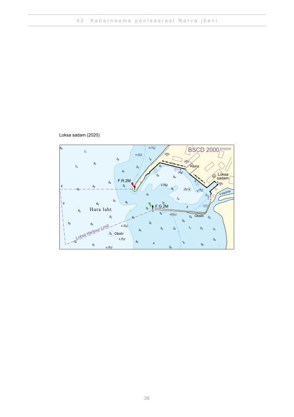
Sataman suunnitelma
Ei navigointikäyttöön. Katso kaikki satamat kartalla.
Katso Nutimeri-kartalla (Transpordiamet, opens in a new tab) — Transpordiamet
Viralliset navigointikartat ja merkinnät, vain tiedoksi — ei ensisijainen navigointiapuväline.
Purjehdusohjeet
Based on a published sailing directions guideVäikelaevu ei teenindata. Vessel movements: laeva ümberpaigutamine on lubatud üksnes sadamakapteni teenistuse loal.[2]
Käytä ajantasaisen merikartan ja navigointivaroitusten kanssa.
- Loksa sadam — aerial panorama (2016)Joel Tammet, estonia360.ee[1]
Depths and dimensional restrictions
The maximum permitted draught is 4.0 m. Published depths alongside are quay 1: 3.8 m, quay 2: 4.0 m, quay 3: 3.9 m and quay 4: 2.9 m. Depths are referenced to EH2000.[2]
Syvyydet laiturikohtaisesti (4)
| quay 2 | 4.0 m |
|---|---|
| quay 3 | 3.9 m |
| quay 1 | 3.8 m |
| quay 4 | 2.9 m |
Lähteet
- Sailing directions Lootsiraamat 4.3 — Kaberneeme poolsaarest Narva jõeni
- Sailing directions Lootsiraamat 4.3 — Kaberneeme poolsaarest Narva jõeni
Julkaistu 12 Sept 2026 · versio 4
Historialliset tuulitilastot
Prevailing winds
How often the wind blew FROM each direction, May–September 2021–2025.
Modelled data, not measured at the harbour
Rings: May (inside) → Sep (outside). Figure at the edge: share of the whole season.
The wind most often came from W (12 % of the season's hours).
- under 3 %
- 3–6 %
- 6–9 %
- 9–13 %
- 13–20 %
- 20 % or more
Regional model data cannot show how sheltered the harbour is, or how the wind moves around its piers and breakwaters.
Data as a table
| Wind from | May | Jun | Jul | Aug | Sep | Season |
|---|---|---|---|---|---|---|
| N | 4.3 % | 3.4 % | 2.2 % | 3.7 % | 4.7 % | 3.7 % |
| NNE | 3.4 % | 4.0 % | 2.7 % | 2.4 % | 2.1 % | 2.9 % |
| NE | 5.0 % | 4.0 % | 5.2 % | 3.3 % | 2.8 % | 4.1 % |
| ENE | 4.9 % | 4.3 % | 6.3 % | 4.8 % | 4.4 % | 5.0 % |
| E | 4.0 % | 4.3 % | 4.0 % | 4.9 % | 4.1 % | 4.2 % |
| ESE | 3.7 % | 4.0 % | 3.4 % | 4.9 % | 5.7 % | 4.3 % |
| SE | 3.4 % | 3.2 % | 4.9 % | 5.8 % | 9.1 % | 5.3 % |
| SSE | 4.1 % | 4.1 % | 5.1 % | 7.4 % | 12 % | 6.5 % |
| S | 5.0 % | 5.5 % | 3.8 % | 7.3 % | 9.2 % | 6.1 % |
| SSW | 6.1 % | 5.9 % | 7.1 % | 8.6 % | 9.2 % | 7.4 % |
| SW | 6.9 % | 9.1 % | 13 % | 11 % | 8.0 % | 9.5 % |
| WSW | 10 % | 10 % | 12 % | 12 % | 7.2 % | 10 % |
| W | 15 % | 15 % | 13 % | 9.5 % | 5.2 % | 12 % |
| WNW | 11 % | 10 % | 9.2 % | 6.6 % | 4.9 % | 8.4 % |
| NW | 6.2 % | 7.8 % | 4.9 % | 4.3 % | 5.8 % | 5.8 % |
| NNW | 5.7 % | 4.3 % | 2.5 % | 2.7 % | 5.3 % | 4.1 % |
| calm | 0.9 % | 0.9 % | 0.7 % | 0.8 % | 0.4 % | 0.7 % |
| % | 100 % | 100 % | 100 % | 100 % | 100 % | 100 % |
Calm: below 0.5 m/s; counted in the total, not in any direction. 18360 valid hours of 18360 expected.
Source: ERA5 reanalysis (ECMWF / Copernicus Climate Change Service), ~25 km grid · model grid point 9.7 km south of the harbour (59.500, 25.750) · May–September 2021–2025, UTC · 18360 valid hours of 18360 expected · Data retrieved 2026-10-07 · Contains modified Copernicus Climate Change Service information (ERA5), CC BY 4.0
Tiedot: satamarekisteri, tietue päivitetty 23 Feb 2026.
Visitor observations
Sailors' experiences, not the harbour's official information.
Käytännön tiedot ja sataman asiakirjat
- Osoite
- Harju maakond, Loksa linn, Tallinna tn 2e, 74806
- Navigointikausi
- 1. jaanuar - 31. detsember
- Satamakapteeni
- Einar Kukk
- Sijainti
- 59.58447° N, 25.70369° E
- Puhelin
- +372 50 37 788
- Sähköposti
- loksa@marsalis.ee
Kaikki rekisterin palvelut
Veesõiduki lastimine ja lossimine · Veesõiduki sildumise võimaldamine · Prügivastuvõtt
Lähimmät satamat
Etäisyys linnuntietä. Lähin satama ei tarkoita, että se sopii veneellesi.
Tallinnanlahti, Paldiski, Naissaari ja Aegna sekä Lahemaan länsiosa Kolgan ja Haran lahdelle. Lyhyitä taivalmatkoja, ja useimmat palvelut auki ympäri vuoden. Kaikki Harjun maakunta ja Tallinna satamat →
Suggest a video for this harbour
Add a 3–30 second video file or a YouTube link. Videos are reviewed before publication; a suitable short clip may become the page hero.