Aseri väikesadam
Lääne-Virun maakunta · Soome laht
Sataman sivu sivustolla mervare.ee ↗
Lyhyesti
- 0.6 mPermitted draughtpilot book
- 3.5 mMaximum lengthregister
- 2.5 mMaximum beamregister
- 0.8 mQuay depthregister
- 1. kesäkuuta – 1. syyskuutaNavigation periodregister
Permitted draught is the limit the sailing directions publish for entering; quay depth is the register's figure for the deepest quay — other quays may be shallower. Neither guarantees a berth that suits your boat.
Palvelut
- PysäköintiUnknown
Hinnat ja saatavuus
Hintaa ei ole julkaistu — kysy satamalta. Varmista satamalta hinta, saatavuus valittuina päivinä ja hintaan sisältyvät palvelut.
Sovi paikasta, hinnasta ja saapumisesta suoraan sataman kanssa.
Saapuminen
Lääne-Viru maakond, Viru-Nigula vald, Aseri alevik, Mere tn 17, 43401
Sataman ympäristö
Ei navigointikäyttöön. Katso kaikki satamat kartalla.
Katso Nutimeri-kartalla (Transpordiamet, opens in a new tab) — Transpordiamet
Viralliset navigointikartat ja merkinnät, vain tiedoksi — ei ensisijainen navigointiapuväline.
Purjehdusohjeet
Based on a published sailing directions guideSildumine omal vastutusel.[2]
Käytä ajantasaisen merikartan ja navigointivaroitusten kanssa.
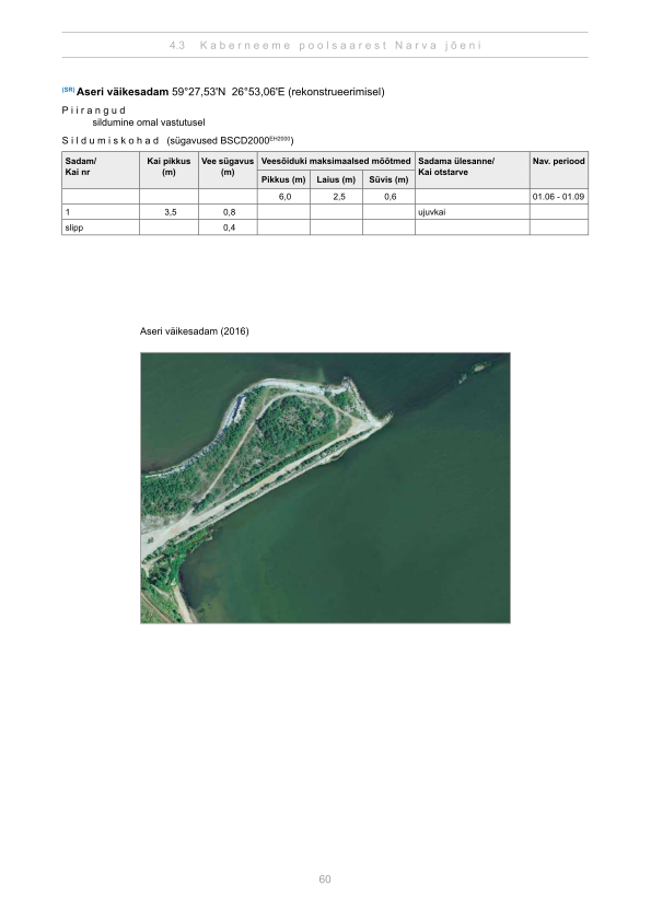
Depths and dimensional restrictions
The maximum permitted draught is 0.6 m. Published depths alongside are quay 1: 0.8 m and quay slipp: 0.4 m. Depths are referenced to EH2000.[2]
Syvyydet laiturikohtaisesti (2)
| quay 1 | 0.8 m |
|---|---|
| quay slipp | 0.4 m |
Lähteet
- Sailing directions Lootsiraamat 4.3 — Kaberneeme poolsaarest Narva jõeni
- Sailing directions Lootsiraamat 4.3 — Kaberneeme poolsaarest Narva jõeni
Julkaistu 12 Sept 2026 · versio 4
Historialliset tuulitilastot
Prevailing winds
How often the wind blew FROM each direction, May–September 2021–2025.
Modelled data, not measured at the harbour
Rings: May (inside) → Sep (outside). Figure at the edge: share of the whole season.
The wind most often came from W (10 % of the season's hours).
- under 3 %
- 3–6 %
- 6–9 %
- 9–13 %
- 13–20 %
- 20 % or more
Regional model data cannot show how sheltered the harbour is, or how the wind moves around its piers and breakwaters.
Data as a table
| Wind from | May | Jun | Jul | Aug | Sep | Season |
|---|---|---|---|---|---|---|
| N | 5.8 % | 4.9 % | 2.4 % | 3.5 % | 4.9 % | 4.3 % |
| NNE | 4.8 % | 4.4 % | 3.7 % | 3.1 % | 2.7 % | 3.7 % |
| NE | 5.8 % | 4.6 % | 6.7 % | 4.7 % | 2.6 % | 4.9 % |
| ENE | 4.0 % | 4.3 % | 5.6 % | 4.5 % | 4.1 % | 4.5 % |
| E | 2.7 % | 3.3 % | 3.4 % | 3.6 % | 4.0 % | 3.4 % |
| ESE | 3.2 % | 3.6 % | 4.2 % | 4.5 % | 3.9 % | 3.9 % |
| SE | 4.5 % | 2.7 % | 5.5 % | 6.3 % | 8.6 % | 5.5 % |
| SSE | 4.8 % | 4.4 % | 4.5 % | 8.3 % | 14 % | 7.2 % |
| S | 5.3 % | 4.9 % | 4.8 % | 7.1 % | 9.2 % | 6.3 % |
| SSW | 5.2 % | 6.9 % | 5.1 % | 7.3 % | 8.3 % | 6.5 % |
| SW | 5.8 % | 6.9 % | 11 % | 11 % | 7.5 % | 8.4 % |
| WSW | 7.6 % | 7.6 % | 12 % | 9.5 % | 6.5 % | 8.6 % |
| W | 13 % | 14 % | 11 % | 8.8 % | 5.3 % | 10 % |
| WNW | 12 % | 12 % | 10 % | 7.7 % | 5.0 % | 9.4 % |
| NW | 7.7 % | 8.1 % | 6.5 % | 5.6 % | 6.1 % | 6.8 % |
| NNW | 7.6 % | 6.5 % | 3.4 % | 3.3 % | 6.4 % | 5.5 % |
| calm | 0.5 % | 0.9 % | 0.4 % | 0.9 % | 0.5 % | 0.7 % |
| % | 100 % | 100 % | 100 % | 100 % | 100 % | 100 % |
Calm: below 0.5 m/s; counted in the total, not in any direction. 18360 valid hours of 18360 expected.
Source: ERA5 reanalysis (ECMWF / Copernicus Climate Change Service), ~25 km grid · model grid point 8 km north-east of the harbour (59.500, 27.000) · May–September 2021–2025, UTC · 18360 valid hours of 18360 expected · Data retrieved 2026-10-07 · Contains modified Copernicus Climate Change Service information (ERA5), CC BY 4.0
Tiedot: satamarekisteri, tietue päivitetty 8 Apr 2026.
Visitor observations
Sailors' experiences, not the harbour's official information.
Käytännön tiedot ja sataman asiakirjat
- Osoite
- Lääne-Viru maakond, Viru-Nigula vald, Aseri alevik, Mere tn 17, 43401
- Navigointikausi
- 1. juuni - 1. september
- Satamakapteeni
- Veigo Raamat
- Sijainti
- 59.45869° N, 26.88365° E
- Puhelin
- +372 56216452
- Sähköposti
- info@gkehitus.ee
Kaikki rekisterin palvelut
Veesõiduki sildumise võimaldamine · Parkla
Lähimmät satamat
Etäisyys linnuntietä. Lähin satama ei tarkoita, että se sopii veneellesi.
Lahemaan itäosa — Käsmu, Eru ja Vergi — sekä Kundanlahti. Syviä suojaisia lahtia niemien välissä. Kaikki Lääne-Virun maakunta satamat →
Suggest a video for this harbour
Add a 3–30 second video file or a YouTube link. Videos are reviewed before publication; a suitable short clip may become the page hero.